


Top>Research>Neighborhood walkability—Discussion on human health and environments from the viewpoint of spatial information science
 Index
Index

Ikuho Yamada [profile]
Education Course
Neighborhood walkability
—Discussion on human health and environments from the viewpoint of spatial information science
Ikuho Yamada
Professor of Spatial Information Science, Faculty of Science and Engineering, Chuo University
Introduction
Online maps and smartphone applications for navigation are now indispensable in our lives. The digitized maps and information on places and locations are called spatial information. Since the Second World War, technologies for handling spatial information have gradually developed in the fields such as national defense, management of land and natural resources, and urban and transportation planning in the western countries including the United States and Canada. In the late 1980s, spatial information science, in which I specialize, was developed with the purpose of giving theoretical bases and frameworks in the field of spatial information, which had been often biased to technological aspects. Under the slogan of the shift from technology to science, spatial information science became an academic discipline that comprehensively discusses not only theories and technologies, but also systems for utilizing spatial information in society and ethics in handling spatial information.
Most activities of humankind are conducted in the space on the Earth, and so the target of spatial information science is broad. One of the major purposes of spatial information science is to help grasp and solve various social issues by gleaning and appropriately analyzing the spatial information about the environments surrounding human livelihoods, such as nature, cities, societies, economies, and cultures. Human health is also studied, and here I would like to introduce my research into “neighborhood walkability” as a case of the application of spatial information science to health issues.
Obesity problems and walkability researches in the United States
You may be unfamiliar with the word “walkability.” This is the noun form of the adjective “walkable,” which was coined by combining “walk” and “able” and means “able to walk or easy to walk,” and indicates how people can walk easily in a local environment. The word walkability was created, in part of environmental approaches for maintaining and improving the health of citizens in the western countries, where obesity is a serious problem. In the United States, it is estimated that about 68% of adults are obese (Note) (Flegal et al. 2010). According to the “National Health and Nutrition Survey in 2012” (published in 2013) of the Ministry of Health, Labour and Welfare, the obesity rate in Japan is about 29% for males and 19% for females. The obesity problem in the United States can be said to be a nationwide epidemic that cannot be dealt with by individual efforts of medical treatment and lifestyle improvement.
In this situation, people have started paying attention to an environmental approach for solving the obesity problem, with the purpose of making urban space healthier and assisting residents there in improving their dietary and fitness habits with less burden. The research into walkability is aimed at increasing the amount of physical activities in a natural manner by making urban areas walkable, that is, easy to walk, and promoting residents to walk in their daily lives. The underlying cause of obesity is the poor balance between energy intake (eating) and energy consumption (physical activities), but external factors, such as the urban and social structures depending on automobiles and the rise of the food service industry, have been pointed out as the reason why the obesity problem has worsened rapidly since the 1990s, and it is considered that the improvement of the environment would alleviate and solve the obesity problem. The regulations for the locations of fast-food shops, the obligation to indicate the calorie of each dish in the menus of restaurants, and the promotion of the construction of supermarkets in declining urban areas, etc., which are sometimes covered in the Japanese mass media, can be said to be some examples of the development of an environment for promoting healthy dietary habits from the aspect of energy intake.
In Japan, the obesity problem is not so serious compared with those in the western countries, and so the above mentioned measures tend to be recognized as special overseas cases. However, the environmental approaches for health, especially the walkability research for promoting physical activities in daily life, have important suggestions for Japan, which will face a super-aging society earlier than any other countries. Walking is a physical activity that can be conducted easily by most people without special tools, regardless of age, gender, and fitness experience. In the research into walkability, we study the casual choice of walking in daily life, for example, for shopping and going to the post office without using an automobile, rather than motivated physical activities, such as workout in gyms and walking for health. In a super-aging society, the health of elderly people is essential for not only individuals, but also the entire society. Accordingly, walkability, which supports health through an easy physical activity in daily life, is expected to serve as health infrastructure underpinning the super-aging society.
Note: The definition of obesity varies between Japan and the United States. In this report, obesity rate is based on the Japanese definition. In Japan, a person is obese when his/her body-mass index (BMI = weight [kg] / (height [m])2) is over 25. In the United States, a person is obese when his/her BMI is over 30, and overweight when his/her BMI is over 25 and less than 30.
3D's of walkability
Then, what kinds of cities are walkable? The physical elements of walkable cities can be classified into the following 3 concepts: population density, pedestrian-friendly design, and land use diversity, and these are collectively called “3D’s of walkability”. The moderate concentration of population invigorates a city, and diverse land use facilitates the development of a compact urban structure. It makes many destinations accessible on foot, and then in conjunction with well-connected road space with quality footways, boulevard trees, and street lamps, etc., walking in daily life becomes safe and comfortable. Therefore, the areas that possess the 3D's are considered to have an environment suited for walking.
In more detail, let me discuss land use diversity (Fig. 1). The circle in the figure represents the range up to 500 m from the house at the center. In the residential district (a), the region within the circle is filled with houses, and destinations accessible on foot are limited. Meanwhile, in the district with a variety of land use (b), residents can visit various destinations on foot and complete daily chores. Next, let me discuss the connectivity of roads (Fig. 2). In the region (a) with a road network like new towns of the Showa period, in which road connectivity was reduced intentionally for reducing the traffic of automobiles passing through residential districts, residents have to detour to reach a geographically nearby destination. On the other hand, in the region (b) where roads are closely connected in a grid pattern, residents can reach a destination at a short distance. In this manner, the land use diversity and the connectivity of roads can be used as indices of the attractiveness and convenience of walking.
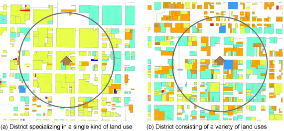
Figure 1: Land use diversity and destinations
(The colors represent the types of land use. This is a schematic diagram and does not show the situation of any specific region.)
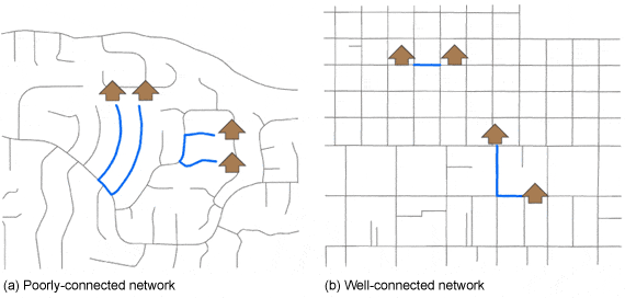
Figure 2: Connectivity of road networks and travel distance
(This is a schematic diagram and does not show the situation of any specific region.)
Calculation of walkability indices and spatial information science
Walkability is gauged through on-site investigations and questionnaire surveys targeted at residents, however these are expensive methods, and difficult to cover a broad area. In this circumstance, a method of utilizing existing spatial information is increasingly used. In this method, the data on land use and roads managed by municipalities are analyzed with geographic information systems (GIS), which are computer software specifically designed for processing spatial information, to calculate walkability indices. The variety and accuracy of indices depend on available data, but this method is inexpensive compared with on-site investigations and questionnaire surveys, and can obtain objective indicators covering a broad area.
Figure 3 shows the calculation result of the index of land use diversity in the area that can be reached within 1 km along the road network from each house of about 5,000 residents in Salt Lake County, Utah, in America. There is a tendency that land is used diversely from the northern to central areas of the county and the diversity is lower in farther areas. Old residential districts and central business districts are dominant in the northern county; from there to the central county, residential and commercial districts coexist, while avenues are lined with commercial facilities; and distant regions from the central county are filled with residential districts. This result well reflects the difference in the land use diversity among regions.
When examining the relation between walkability and health from the viewpoint of spatial information science, we usually start with calculating several indices of 3D’s described above to comprehensively evaluate the walkability of a local area. We then statistically analyze the relation between health indicators, such as obesity level, and walkability indices. We often use the methods of spatial statistics, which were developed by adding the positional elements in a two-dimensional space to general statistical methods. With these methods, it is possible to analyze the linkage between the environments and health more clearly. In our research in Salt Lake County, 17 walkability indices were calculated, and it was found that most of the indices are significantly correlated with BMI of residents (Yamada et al. 2012).
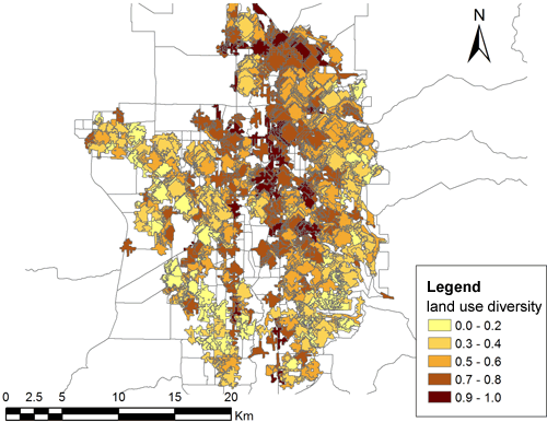
Figure 3 Spatial distribution of land use diversity in Salt Lake, Utah
(Data provision: The DIGIT Lab at the University of Utah and Utah Population Database)
Conclusion
As mentioned above, neighborhood walkability is a concept developed in the western countries, where the obesity problem is serious, and the research into it is still immature in Asian countries, including Japan. Even in the western countries, case studies regarding specific regions are dominant, and there have been few studies that have identified clear causal relation between walkability and health to be reflected in urban planning. In order to improve walkability, it is necessary to physically change urban structures. This would cost a lot of money and time, and so long-term empirical researches and social experiments are required for reflecting the concept of walkability in urban designs. In addition, when discussing Japanese cities, that have different social and cultural backgrounds from those in the western countries, it is important to develop an appropriate walkability concept considering Japanese situations.
Walkable cities that promote walking are also ecological cities in which residents are less dependent on automobiles and energy consumption is curbed. In Japan, currently facing issues in citizens’ health, natural resources, and environments, the development of cities with high walkability may become a primary measure for tackling the problems. In the field of walkability researches, it is imperative to conduct many researches into the characteristics of Japanese cities and acquire the knowledge that can be utilized for urban planning.
References
- The Ministry of Health, Labour and Welfare (2013), “Overview of the Results of National Health and Nutrition Survey in 2012”
 (Last accessed: Feb. 2, 2014)
 - Flegal, K.M., M.D. Carroll, C.L. Ogden and L.R. Curtin (2010). “Prevalence and trends in obesity among US adults, 1999-2008.” JAMA 303 (3): 235-241.
- Yamada, I., B.B. Brown, K.R. Smith, C.D. Zick, L. Kowaleski-Jones, and J.X. Fan (2012). “Mixed land use and obesity: An empirical comparison of alternative land use measures and geographical scales.” The Professional Geographer 64 (2): 157-177.
- Ikuho Yamada
Professor of Spatial Information Science, Faculty of Science and Engineering, Chuo University -
Ikuho Yamada was born in Tokyo, and graduated from the Faculty of Engineering, the University of Tokyo in 1997. Yamada completed the Master’s program of the Department of Urban Engineering, the University of Tokyo in 1999. After earning a doctoral degree in geography at the University at Buffalo, the State University of New York in 2004, Yamada served as Assistant Professor in Indiana University-Purdue University Indianapolis and the University of Utah, and Associate Professor of the Center for Spatial Information Science, the University of Tokyo from 2010 and the Interfaculty Initiative in Information Studies, the University of Tokyo from 2011 before assuming the current position in 2013.
Yamada conducts various researches into the relation between the health of residents and their living environments, by applying quantitative spatial analysis methods. Her major publication includes Statistical Detection and Surveillance of Geographic Clusters (2009; co-authored by Professor P. Rogerson of the State University of New York), which broadly describes the methods for analyzing and monitoring space.

- Research Activities as a Member of Research Fellowship for Young Scientists (DC1), Japan Society for the Promotion of Science (JSPS) Shuma Tsurumi
- Important Factors for Innovation in Payment Services Nobuhiko Sugiura
- Beyond the Concepts of Fellow Citizens and Foreigners— To Achieve SDGs Goal 10 “Reduce Inequality Within and Among Countries” Rika Lee
- Diary of Struggles in Cambodia Fumie Fukuoka
- How Can We Measure Learning Ability?
—Analysis of a Competency Self-Assessment Questionnaire— Yu Saito / Yoko Neha - The Making of the Movie Kirakira Megane