


Top>Opinion>The Potential of the Northern Sea Route
 Index
Index

Shigeki Toriumi [Profile]
The Potential of the Northern Sea Route
Shigeki Toriumi
Assistant Professor, Faculty of Science and Engineering, Chuo University
Areas of Specialization: Information Engineering, Social System Engineering
The Northern Sea Route at present
The Arctic Ocean is the sea surrounded by the Eurasian and North American continents, with the North Pole at its center. The shipping route that passes through the Arctic Ocean to connect the Pacific Ocean with the Atlantic Ocean is called the Northern Sea Route. It is roughly divided in two-the route running above Russia in the Eurasian continent, the Northeast Passage, and the route running above Canada in the North American continent, the Northwest Passage. Known as a shipping route, it has been very difficult for ordinary vessels to pass through the Northern Sea Route, which is covered in sea ice and drift ice. In recent years, however, the potential of the route has emerged in terms of its use for commercial shipping, as the sea ice is shrinking due to the effects of climate change. This could be one of the very few beneficial results of global warming. In fact the disappearance of sea ice in both the Northeast Passage and the Northwest Passage was reported in September 2008 by the Global Ice Center of Weathernews Inc., the first such recorded event since observation by satellites began in 1978. In August 2010, a supertanker owned by Sovcomflot, the largest shipping company in Russia, passed through the Northeast Passage to transport 70,000 tons of light crude oil condensate from the port of Murmansk in Russia to China.
Why the Northern Sea Routes are getting so much attention
There are three reasons for all the attention being focused on the Northern Sea Route. Firstly, the route would significantly reduce sailing distances between Europe and East Asia and between the East Coast of the United States and East Asia. For example, the current route connecting Felixstowe in the UK to Pusan in South Korea via the Suez Canal is approximately 10,700 nautical miles long, but using the Northeast Passage would cut this to about 7,400 nautical miles, a reduction of around 30%. Shorter distances mean less fuel consumed and fewer days required for shipping.
Another reason is the lower possibility of encounters with pirates along the Northern Sea Route. At present, there is frequent damage from pirates boarding vessels in the Straits of Malacca and the Gulf of Eden (off the coast of Somalia) which are traveling back and forth between Europe and East Asia via the Suez Canal. Rounding Africa's Cape of Good Hope in order to avoid pirates in the Gulf of Eden greatly increases the distance of the voyage, while passing through the Gulf of Eden in spite of the risk of piracy causes marine insurance premiums to skyrocket. Both of these ways increase the shipping cost for shipping companies and cargo owners. The Northern Sea Route, on the other hand, has seen hardly any reports of piracy. (Of course, there hasn't been any shipping along them yet.)
The third reason relates to the transportation of resources lying under the Arctic Ocean. There are thought to be vast reserves of oil and natural gas in the region, and the ocean's coastal nations are studying the extraction of such reserves and their marine transportation to natural resource importing countries such as Japan and China. Japan needs to cultivate a diversity of resource exporting partners and is watching the situation very carefully from the perspective of risk management.
Effect on shipping
Regarding the effect of reducing sailing distances in the first reason for the increased attention mentioned above, analysis using actual vessel movement data and operations research methods shows there would be a large reduction effect on the voyage distances of shipping traveling between the East Coast of the United States and East Asian countries such as China, South Korea, and Taiwan.
Let's look at the shortened voyage distances in terms of the number of days at sea. Passing through the Northern Sea Route at current voyage speeds would cut the time spent at sea in proportion to the shortened distance. If we calculate this reduction in shipping time, it comes to about 16 days maximum and about 3.5 days on average. For individual vessels (since there are sometimes multiple reduced voyages) the average reduction is about six days. Alternatively, supposing the present number of days at sea is maintained, nautical speed could be reduced by around 2 to 4 knots. Taking into account that the fuel consumption per unit time of a voyage is, characteristically for vessels, roughly proportional to the vessel speed cubed, we can estimate a reduction in fuel consumption of about 40 to 50%.
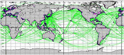
Figure 1: Digital shipping route network
Used to estimate the shortening effect on voyage distances
By specifying the port of origin and port of arrival, the user can search for the shortest shipping route, rather like a car navigation system.
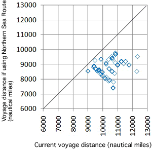
Figure 2: Comparison of voyage distances
Plotted diagrams show the distances of voyages.
Towards the opening of the Northern Sea Route
There are also many issues that must be resolved ahead of the commercial utilization of the Northern Sea Route. For instance, when navigating the Northeast Passage, vessels currently need a Russian license of ice tolerance. At present, hardly any operational ships meet the ice tolerance levels required, so what is necessary is a switch to ships with ice tolerance (that is, the construction of ships that meet ice tolerance requirements). For safe operation, meteorological stations must be established and, because they pass through subpolar locations, require measures against geomagnetic storms such as observation equipment. Furthermore, rights disputes between related countries sometimes reappear whereupon the political settlement of a complex set of ideas is needed.
The Northern Sea Route will undoubtedly have a huge impact on the marine distribution of all countries worldwide. Being closer to the Bering Strait-the entrance to the Northeast Passage-gives Japan an advantage in terms of location as a hub port, as compared with the other busy East Asian hubs of Singapore, Hong Kong, and South Korea (Pusan). The feasibility of the Northern Sea Route will have to be carefully considered in determining policy and conducting business activities going forward.
- Shigeki Toriumi
PhD (Eng), Assistant Professor, Faculty of Science and Engineering, Chuo University
Specialized fields: Information Engineering, Social System Engineering - Shigeki Toriumi was born in Yokosuka-shi, Kanagawa Prefecture. He graduated from the Faculty of Science and Engineering, Chuo University in 1997 before completing his master's degree in Information and Systems Engineering at the Graduate School of Science and Engineering, Chuo University in 1999. After joining Canon Inc., he obtained his PhD in Information and Systems Engineering from the above Graduate School in 2007. He has held his current position since 2008, after serving as a researcher at the National Maritime Research Institute. He is a member of the Operations Research Society of Japan, the GIS Association of Japan, the Japan Society for Industrial and Applied Mathematics, the City Planning Institute of Japan, and the Japan Society of Traffic Engineers. Professor Toriumi is currently engaged in research into mathematical methods and practical methods for solving problems with traffic systems-including rail, shipping, and aviation-and closely related urban, regional, and environmental issues.
- Spatial Information Laboratory


- Research Activities as a Member of Research Fellowship for Young Scientists (DC1), Japan Society for the Promotion of Science (JSPS) Shuma Tsurumi
- Important Factors for Innovation in Payment Services Nobuhiko Sugiura
- Beyond the Concepts of Fellow Citizens and Foreigners— To Achieve SDGs Goal 10 “Reduce Inequality Within and Among Countries” Rika Lee
- Diary of Struggles in Cambodia Fumie Fukuoka
- How Can We Measure Learning Ability?
—Analysis of a Competency Self-Assessment Questionnaire— Yu Saito / Yoko Neha - The Making of the Movie Kirakira Megane