

Examining the Process Leading Up to Massive Slope Failures
Heitaro Kaneda/Professor, Faculty of Science and Engineering, Chuo University
Areas of Specialization: Tectonic Geomorphology, Mountain Geomorphology and Glacial Geomorphology
1. A massive slope failure that completely changed the Joganji River
In the early hours of April 9, 1858 (February 26, 5 of Ansei era), at the end of the Edo Period, the Atotsugawa fault system, which stretches from the present-day Hida region in Gifu Prefecture to the vicinity of Tateyama Mountain Range in Toyama Prefecture, suddenly ruptured and caused the Hietsu Earthquake (magnitude 7.3-7.6). The seismic ground motion caused great damage not only to mountain villages along the Atotsugawa fault system and the castle town of Toyama, but also to far away locations such as Kanazawa and the Fukui Plain. One impressive phenomenon that made this earthquake widely known to the public is Tateyama Tombi Landslide, a massive slope failure that occurred in the Tateyama caldera at the eastern end of the Atotsugawa fault. At nearly the same time as the earthquake, the western slopes of two mountains, Mt. O-Tombiyama and Ko-Tombiyama, suffered a massive slope failure. Sediment from the failure deeply buried the Yukawa and Magawa valleys, the upriver portions of the Joganji River. The sediment also completely destroyed Tateyama Onsen, which had been located in the valleys. Researchers estimate that the amount of collapsed sediment at this time reached a volume of at least 100 million m3(1). Considering that a massive slope failure is generally defined as having sediment volume of at least 1 million m3, it is easy to imagine the immense size of the failure.
The impact of this massive slope failure reached even further. A natural dammed lake was created by sediment that blocked the river. This natural dam collapsed twice, two weeks and about two months after the earthquake, causing large-scale debris flows which struck the Joganji River alluvial fan and the Toyama Plain downriver of the dam. The scale of the second debris flow was especially large, and it is said to have caused the drowning deaths of 135 people and left fields with 4.5 million kilograms of rice destroyed and barren. Afterwards, landslides and floods began to occur on the Joganji River every time it rained heavily. The river, which had been relatively stable until then, changed completely into a raging river. In response to this situation, erosion control work by Toyama Prefecture began in 1906 at the Tateyama caldera upriver of the Joganji River. Later on, erosion countermeasures were taken over as a project under the direct control of the Japanese national government. Efforts to prevent sediment runoff downriver continue to this day.
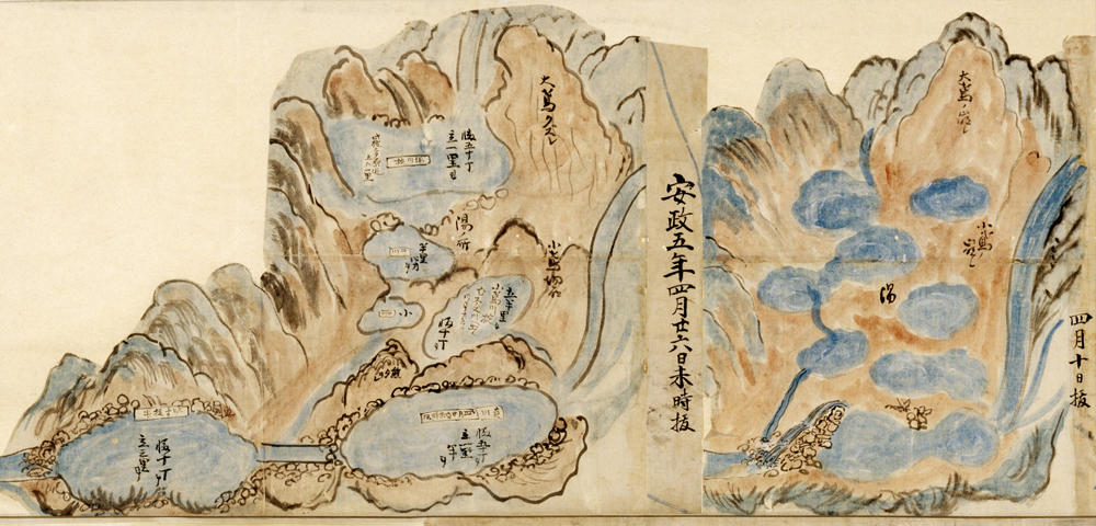
Image of slope failure at Mt. O-Tombiyama in the Tateyama Mountain Range
(Taken from the collection of the Toyama Prefectural Library)
2. There is always a long process leading to major phenomena
In this way, the impact of a massive slope failure that occurs during a major earthquake is unimaginable. In addition to the direct damage caused by burial under collapsed sediment, slope failures can also lead to secondary and continual disasters in downriver areas; for example, the formation and collapse of dammed lakes and the frequent occurrence of debris flows due to subsequent heavy rains. Furthermore, when collapsed sediment rushes into a body of water such as the sea, it can generate a huge tsunami. Since slope failures can be a major obstacle to relief activities and reconstruction after a major earthquake, obtaining advance understanding in regard to the possibility of occurrence, location, and scale of a massive slope failure is extremely important in terms of disaster prevention measures.
However, because the number of massive slope failures in this class is limited throughout the historical timeline, researchers still lack a clear understanding in regard to the type of location and process that lead to a massive failure. Generally speaking, whether it is an earthquake, a volcanic eruption, or any other natural phenomenon, the larger the scale of the event, the lower the frequency of its occurrence. This means that large events have a correspondingly long process leading up to occurrence. For example, a magnitude 9-class earthquake in the Japan Trench, such as the Great East Japan Earthquake in 2011, occurs only once every several hundred years. This means that it takes a correspondingly long period of time to accumulate energy equivalent to magnitude 9 on the fault (It also means that the fault is strong enough to withstand such energy). Stated differently, massive events never occur suddenly without warning. Accordingly, if there were a way to grasp the process leading to occurrence and the current state within that process, there would be a chance to evaluate the possibility of occurrence.
3. What is the process leading to a massive slope failure?
Now, what about a massive slope failure? In fact, researchers have been recently focusing on a process called "deep-seated gravitational slope deformation (DSGSD)" as a precursor and preparatory phenomenon of massive slope failure. DSGSD is a phenomenon in which a mountain is slightly deformed by its own weight without developing a clear slide surface. The progress of this phenomenon is estimated from micro-topography such as small scarps and small depressions distributed on and around mountain ridges (called DSGSD geomorphic features). However, it had been extremely difficult to detect DSGSD on mountains covered with vegetation because the scale of those features is on the order of as small as several meters or even several dozen centimeters in some cases. The growing application of airborne laser scanning technology (a type of topographical surveying method) over the past 15 years, however, has made it possible to map in detail the existence of such micro-topography hidden under vegetation. The effect of this new surveying method is enormous. One example is the numerous massive slope failures that occurred during the torrential rain on Kii Peninsula in 2011. As a result of analyzing the airborne laser scanning data taken before the landslides, researchers clarified that all failures occurred on slopes which had previously undergone DSGSD(2). This indicates that DSGSD can be an important clue for the prediction of massive slope failures. However, these slope failures have a sediment volume on the scale of 1 million to 10 million m3. Therefore, researchers have made little progress in clarifying the process leading to enormously destructive massive slope failures with sediment volume on the scale of tens of millions to over 100 million m3.
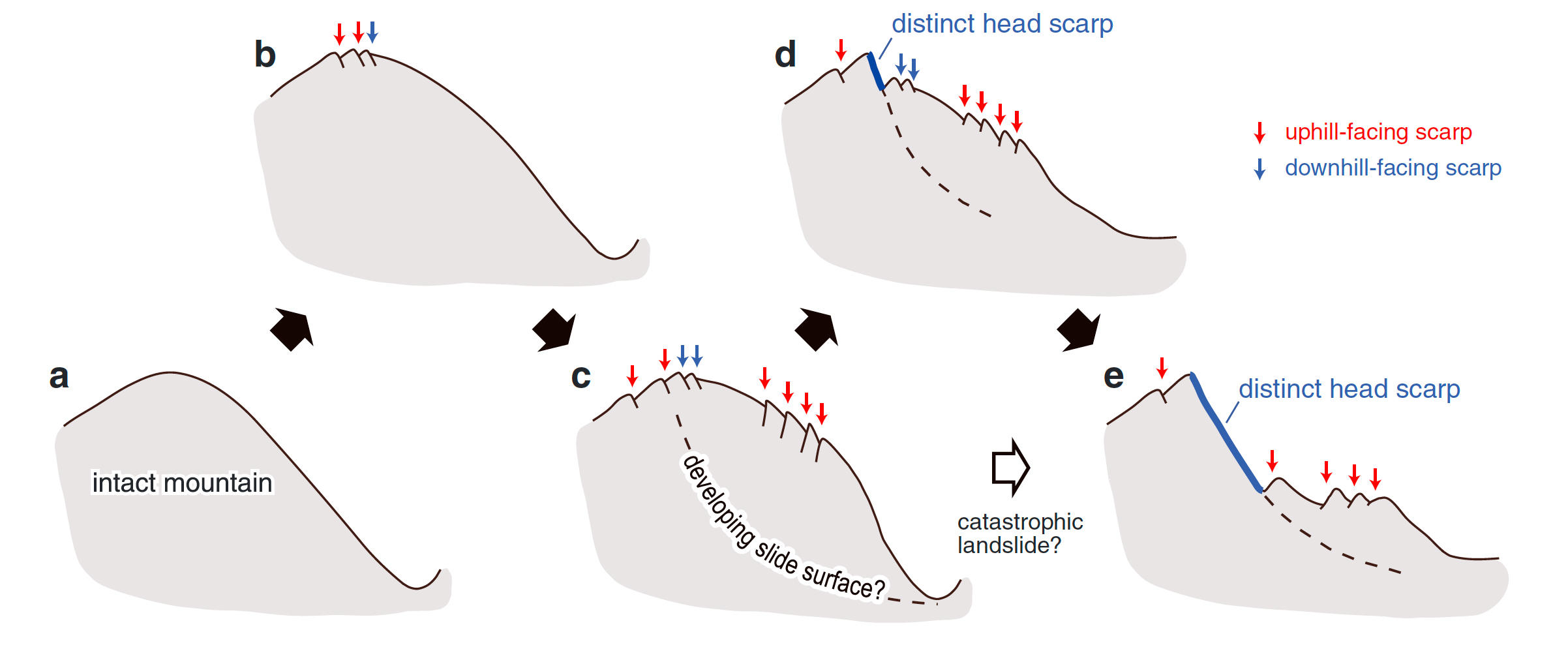
Topographic development model from intact mountain to massive slope failure through DSGSD(3)
Given these facts, our research group, which consists of researchers and students from multiple universities and research institutes centered on Chuo University, is conducting on-site geological surveys and research on the DSGSD that preceded the 1858 Tateyama Tombi Landslide. Unlike the case of the torrential rains on the Kii Peninsula in 2011, it is no longer possible to reproduce the topographical details prior to the occurrence of the failure. Nonetheless, fragmentary topographical traces of DSGSD still remain around the edge of the massively collapsed landform. By using those topographical traces as clues, our research group seeks to clarify when DSGSD leading to the Tateyama Tombi Landslide began and why a massive slope failure occurred in that location in 1858 (in other words, why massive slope failure did not occur in other locations), while also considering the relationship with the Atotsugawa fault system.
4. Actual survey
I will now briefly introduce our actual survey. In order to clarify when DSGSD began, we need to determine a specific age. Therefore, our research group conducts boring excavation in small depressions (small ponds and marshes) developed by DSGSD. We then analyze volcanic ash or conduct radiocarbon dating to estimate when the ponds or marshes formed, which is also the timing at which DSGSD occurred. Furthermore, we determine the timing of other massive slope failures that occurred in the surrounding area by measuring the amount of material (cosmogenic nuclides; specifically, beryllium-10) that has accumulated due to the exposure to cosmic rays on the surface of boulders produced during the slope failure.
These methods are easy to describe but difficult to implement. We conduct research at the site of a massive slope failure in the steep North Japanese Alps, and the environment is extremely harsh. There is no way to access the site by car. There is not even a mountain trail. Fortunately, with the cooperation of a mountain hut located a bit away from the survey site, we were able to have our equipment transported to the hut by regular helicopter flights. However, we still have to carry the equipment to the site and conduct excavation on our own. Despite our best efforts to decrease the weight of our equipment, the "portable percussion coring system" which we built has a total weight of over 100 kilograms. To access the research site, researchers must carry up to 30 kilograms of research equipment on their back and traverse a ridgeline at altitudes exceeding 2,500 meters. We then use an engine-driven striking device to conduct boring excavation by ourselves. Researchers must also carry back the precious drilling cores and rock samples which we collect. Even after bringing samples back to our laboratory, a huge amount of time and effort (and perseverance) is required for processing and analysis. Field survey research is a prolonged struggle that sometimes takes several years from planning the survey to obtaining results.
Although our research project has just begun, a preliminary boring survey conducted last year (2022) revealed that the small gravitational ponds and marshes that still exist today were not formed during the Tateyama Tombi Landslide in 1858. Instead, we determined that they were formed by DSGSD that started at least several thousand years ago before the Tateyama Tombi Landslide, and that a subsequently long process led to the occurrence of the Tateyama Tombi Landslide. Over the next few years, I hope to frequently visit Tateyama and analyze the full picture of the process leading up to the Tateyama Tombi Landslide.
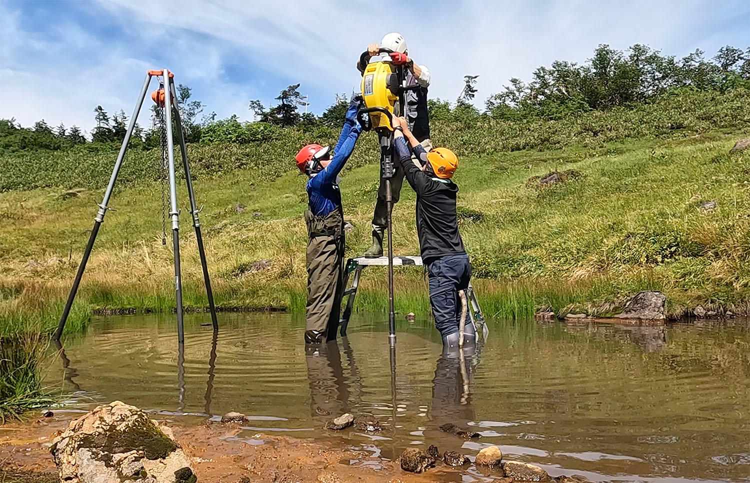
Boring excavation work in a small gravitational pond immediately above Tateyama Tombi Landslide
(photographed by Dr. Daisuke Ishimura, Tokyo Metropolitan University)
[Notes]
This research is being carried out with the permission of the Ministry of the Environment, with grants-in-aid for scientific research from the Ministry of Education, Culture, Sports, Science and Technology, and with support from the Earthquake Research Institute (the University of Tokyo) and the Disaster Prevention Research Institute (Kyoto University) in 2022.
[Reference Literature]
(1) Ouchi, S. and Mizuyama, T. (1989), Volume and movement of Tombi Landslide in 1858, Japan, Trans. Jpn. Geomorphol. Union,10-1,27-51.
(2) Chigira, M., Tsou, C.Y., Matsushi, Y., Hiraishi, N, and Matsuzawa, M. (2013), Topographic precursors and geological structures of deep-seated catastrophic landslides caused by Typhoon Talas, Geomorphology, 201, 479-493.
(3) Kaneda. H. and Kono, T. (2017), Discovery, controls, and hazards of widespread deep-seated gravitational slope deformation in the Etsumi Mountains, central Japan, J. Geophys. Res. Earth Surface, 122, 2370-2391.
Heitaro Kaneda/Professor, Faculty of Science and Engineering, Chuo University
Areas of Specialization: Tectonic Geomorphology, Mountain Geomorphology and Glacial GeomorphologyHeitaro Kaneda was born in Kobe City. In 2004, he completed the Doctoral Program in the Graduate School of Science, Kyoto University. He holds a PhD in science.
He served as a research fellow at the Japan Society for the Promotion of Science, researcher at the National Institute of Advanced Industrial Science and Technology, and Associate Professor in the Faculty of Science, Chiba University before assuming his current position in 2020.His areas of expertise are tectonic geomorphology, mountain geomorphology and glacial geomorphology. He conducts research on natural disasters and climate change based on field surveys mainly in mountainous areas such as the mountains spanning the Echizen and Mino regions of Japan, the Japanese Alps, and rocky outcrops in Antarctica.
- Share articles