

Memories of Natural Disasters Unraveled by Studying History
Kohei Nishikawa
Associate Professor, Faculty of Letters, Chuo University
Area of Specialization: Medieval Japanese History
1. The meaning of studying natural disaster history
As the Heisei Period draws to a close, we have more opportunities to reflect on the era through projects by the mass media. Although the Heisei Period will be remembered in infinitely different ways depending on each individual, it was certainly an era in which the natural environment underwent changes on a global scale. Furthermore, the Japanese archipelago was struck by numerous natural disasters including the Great Hanshin-Awaji Earthquake (1995), the Great East Japan Earthquake (2011), and the Heavy Rains of July 2018. Indeed, the Heisei Period can be described as an era during which people confronted natural threats, and were forced to reevaluate their personal lifestyle and social values.
People living modern times have unconsciously believed that human beings can control the natural environment through the development of science and industry. Accordingly, when an unexpected natural disaster occurs, we describe it using terms such as "once in a century disaster." In many cases, people are at a total loss at how to respond to such threats.
When looking back throughout history, people living on the Japanese archipelago have repeatedly experienced a variety of large-scale natural disasters. Throughout this history, how have Japanese people responded when struck by a natural disaster? Also, what kind of knowledge and technology did they cultivate for dealing with disasters? By searching for the solutions to these questions, we can learn how to respond to natural disasters through perspectives differing from contemporary values. Perhaps this search will become a driving force for creating a new relationship between nature and people. Based on this thinking, let's search history to find responses to natural disasters.
2. Response to natural disasters found in historical materials
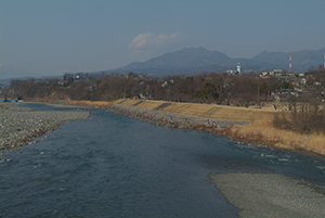
Shingen-zutsumi embankments and the Kamanashi River
Behind the modern embankment covered with trees, there is a main embankment that has existed since the Sengoku Period.
Let's recall Kai Province (Yamanashi Prefecture) in the Sengoku Period during the 16th century. Surrounded in all directions by lofty mountains such as the over 3,000-meter Akaishi Mountains (Southern Alps), the Yatsugatake Mountains, and the Misaka Mountains, the Kofu Basin receives rivers including the Kamanashi River and the Fuefuki River. While the basin was blessed with rich water resources, the region was struck by floods so frequently that a legend in which the basin had originally been a vast lake had been passed down until medieval times.
The main character of the lake legend is Kunitate Daimyojin, God of river management who was said to have excavated the southern mountains from the basin and flushed water from the lake. Kunitate Daimyojin was enshrined at Mt. Naeshiki (Nirasaki City) in the western basin, an area reached by traveling upstream along the Midai River, which was a tributary of the Kamanashi River. In contrast, in the center of the basin, a different lake legend had the main character Inazumi Jizo, Buddha of good harvest. The narratives Jizo Bosatsu Reigenki and Jizo Bosatsu Sangoku Reigenki, which were supposedly written before the 15th century, suggest that a flood caused Inazumi Jizo to descend from the area around Mt. Naeshiki to the center of the basin. In the light of these narratives, it is believed these two lake legends were originally the same legend, and the legends are thought to have been born from the widespread belief in a god that brought water management and bountiful harvests to the basin, around the Kamanashi River which used to flow in the center of the basin.
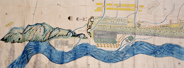
Illustration of the Shingen-zutsumi embankment (from the collection of the Yamanashi Prefectural Museum)
A copy of an illustration of the Shingen-zutsumi embankment that was drawn in 1688. The embankment dammed the channel of the Kamanashi River, which had flowed in the upper area of the illustration (east).
In this climate of the Kai Province, construction of the Shingen-zutsumi embankment was started by Shingen Takeda, a feudal warlord who ruled over the area in the Sengoku Period. Constructed in Ryuo (Kai City) in around 1560, the Shingen-zutsumi embankment helped protect the Kofu area against flood damage by damming the Kamanashi River flowing in the center of the basin and changing the flow. The construction of Shingen-zutsumi continued until the 18th century. This embankment was the beginning of large-scale flood damage prevention works that changed the landscape of the basin.
The Shingen-zutsumi embankment was protected from floods by residents in the local community. For example, on July 6 in what is thought to have been 1563, the Takeda Family issued shuinjo (official documents) which ordered more laborers from present-day Kofu City and 15 nearby villages to implement construction for relieving flooded conditions (the shuinjo is from the collection of the Hosaka Family). In the Edo Period, when the Kamanashi River was swollen and the Shingen-zutsumi embankment had collapsed, the Ryuo Village circulated a document pursuant to the contents of the shuinjo to each village in order to recruit more labor. Therefore, this shuinjo is thought to have been an official document issued by the Takeda Family to Ryuokawarasyuku district (Ryuo Village), which was a home ground of the Shingen-zutsumi embankment.
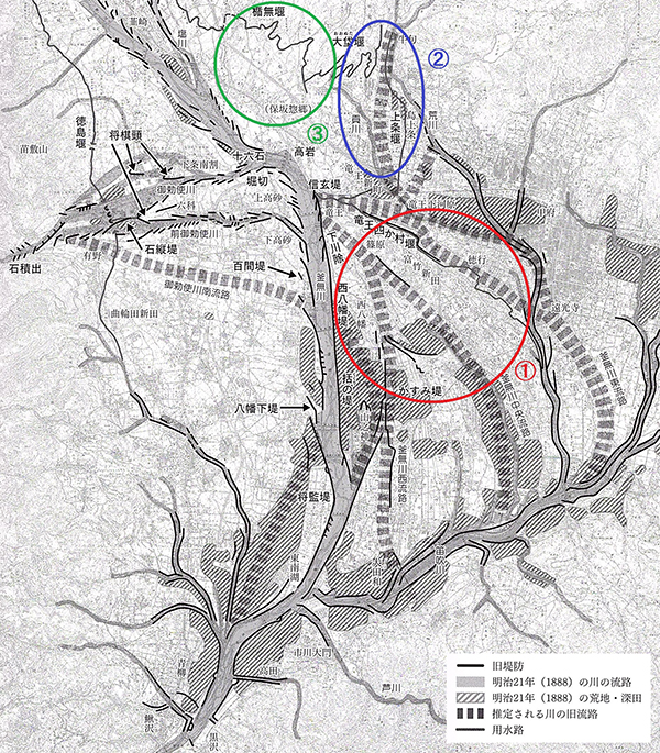
Map of Kofu Basin
From the Sengoku Period to the Edo Period, the Kamanashi River flowed in several channels throughout the Kofu Basin. Sections (1) to (3) show areas where laborers were mobilized for river management construction of the Shingen-zutsumi embankment.
*This figure was made by editing a portion of the display entitled Rich Water Resources in Yamanashi: Shingen-zutsumi and Residents of Kai City (Yamanashi Prefectural Museum in 2013).
*This figure was made using edited versions of 1/25,000 scale maps issued by the Geospatial Information Authority of Japan for areas such as Northern Kofu, Kofu, Ichikawadaimon, Nirasaki, Ogasawara and Kajikazawa.
When examining the villages described in ancient documents by region, we find that they are divided into three regions; (1) the Kamanashi River basin along the lower courses of the Shingen-zutsumi embankment, (2) the Ku River basin, which is inferred to have joined the Kamanashi River downstream along Shingen-zutsumi, and (3) the Akasaka Plateau and the foot of Mount Kayagatake upstream along Shingen-zutsumi. Among these regions, (1) was damaged directly by flooding when Shingen-zutsumi collapsed. In region (2), it is inferred that there was a possibility that the Ku River could overflow when the Kamanashi River was swollen and the Ku River could not merge with the Kamanashi River. This resembles the Heavy Rains of July 2018 in which flooding was caused by the Oda River, which flows through the Mabicho district of Kurashiki City, Okayama Prefecture. Flooding was due to rising water level of the Takahashi River, which is a merging destination of the Oda River. Similarly, this kind of back-water phenomenon is thought to have occurred in the Ku River.
Now, what kind of relationship exists between region (3) and the Shingen-zutsumi embankment? Region (3) is located upstream from Shingen-zutsumi and at a higher elevation, so it is not directly damaged even if Shingen-zutsumi breaks and flooding occurs. Some residents of Ryuo Village, the origin of Shingen-zutsumi, had relocated from region (3) during the Sengoku Period. During the Edo Period, Ryuo Village was recognized as a village composing Hosaka Township, a municipality belonging to region (3) and whose laborers had been mobilized. Accordingly, even when not exposed to flooding damage like in regions (1) and (2), people living in region (3) prioritized relationships among the regions and accepted the mobilization of laborers. When shifting our gaze to the present day, concerns have been raised regarding the limitations of people living in an area struck by natural disasters to fulfill a leading role in relief and reconstruction. Through agreements on disaster relief and reconstruction support among municipalities, systems are being constructed in which municipalities struck by disasters are supported by other unaffected municipalities. In this respect, when viewed from a different perspective, the act of deploying laborers in region (3) when the Shingen-zutsumi embankment broke can be described as a form of support for disaster areas in the Sengoku Period. In the Kofu Basin during the 16th century, measures had been taken for water management through a broad and diverse network in regional societies.
3. Shift in how nature is viewed in early modern period
Now, what philosophy did people in the early modern period have for river management? In 17th century, a group of discontinuous embankments called Kasumitei existed along the lower course of the Ryuo Shingen-zutsumi. According to the Kaikokushi (records of the Kai Province) edited in the 19th century, Kasumitei used to be a bank of the Kamanashi River before continuous banks were constructed in the 18th century. Kasumitei prevented large-scale flood damage because there was appropriate flood drainage from the intervals between embankments during times of flooding and the embankment itself did not collapsed. Conversely, in the 18th century, the construction of continuous banks as in modern times caused gravel to accumulate and the river bed to rise. This made it necessary to engage in costly construction to raise embankments. Also, when banks collapsed in the overflow of the river, the large amount of gravel accumulating on the river bed flowed and resulted in long-term damage.
In this way, until the 17th century, river management was implemented in a way which accepted damage of a certain scale in order to prevent large-scale disasters. In other words, by the Sengoku Period, residents of the Kai Province had cultivated sandbanks in the river. These residents took natural disasters into account when planning their daily life and land use. However, from the 18th century, the development of civil engineering skills caused river management to change into a disaster prevention system aimed at completely eliminating natural disasters. These measures were based on the policy of the Edo Shogunate of Japan which led to modern development. Specifically, the Shogunate aimed to improve productivity and efficiency by cultivating the river beach and controlling the natural environment. Before long, people forgot threats of nature beyond their control and continued to develop without expecting the occurrence of natural disaster. The result was large-scale damage and huge sacrifices in society.
As we approach a new era, we must reflect on our history when rethinking how nature is recognized in modern society. There is a need to reconsider harmony between nature and people.
Reference documents
- Kohei Nishikawa, River Bank Management and Regional Societies in the Sengoku Period: In the Case of Kai Province, Rekishi-Gaku Kenkyu Vol. 889, 2012 and Development, Environment and Regional Society in the Late Medieval Ages, Koshi Shoin, re-recorded in 2012.
- Kohei Nishikawa, Emergence of the Legend of Lake in Kai Province, Yamanashi Prefectural Museum Bulletin, No. 8, 2014.
- Kohei Nishikawa, Construction of Irrigation Ditch and Landscape on the Local Temple and Shrine during the Sengoku Period: Focusing on the Case of Kubo-Hachiman Jinja Shrine in Kai Province, Journal of the Faculty of Letters (History) Vol. 31, Faculty of Letters, Chuo University, 2018.
*This article is a part of research results supported by JSPS Grant-in-Aid for Scientific Research (C). Also, it is based on results of research activities at the Yamanashi Prefectural Museum.
- Kohei Nishikawa
Associate Professor, Faculty of Letters, Chuo University
Area of Specialization: Medieval Japanese History - Kohei Nishikawa was born in Kanagawa Prefecture in 1974.
He graduated from the Faculty of Letters, Chuo University in 1996.
He completed the Master’s Program in the Graduate School of Letters, Chuo University in 1998, and completed the Doctoral Program in the same graduate school in 2011.
He holds a PhD in history from Chuo University.
As a curator, he oversaw the construction and management of the Yamanashi Prefectural Museum and Fujisan World Heritage Center.
He was appointed to his current position in 2017.
His research themes include the history of medieval Japanese villages, environmental history (focus on water resources), and origins and formations of networks for warrior clans.
His main writings include Development, Environment and Regional Society in the Late Medieval Ages, (sole author; Koshi Shoin, 2012), Kai Genji: Origin and Network of Warrior Clans, (written and edited; Ebisukosyo Publication, 2015) and more.
- Share articles